URBAN
REAL ESTATE & COUNCILS

Aerial Property Photography and Videography

-
Service Overview: Use the DJI Air 3 to capture stunning 4K aerial videos and high-resolution photographs of residential, commercial, and industrial properties. This service is ideal for real estate listings, promotional content, and marketing campaigns, offering a unique perspective that traditional photography cannot achieve.
-
Key Benefits
-
Stunning Visuals: High-definition aerial footage enhances the appeal of properties, providing a clear, professional view that helps attract potential buyers or investors.
-
Efficient Coverage: Drones allow for fast, efficient coverage of large properties, reducing the time and resources needed compared to traditional photography methods.
-
Cost-Effective Marketing Tool: Save on expensive ground-based equipment, labor, and permits. Drones provide high-quality content at a fraction of the cost.
-
Cinematic Shots: With advanced stabilization and camera technology, drones capture smooth, cinematic shots that bring out the best in your properties.
-
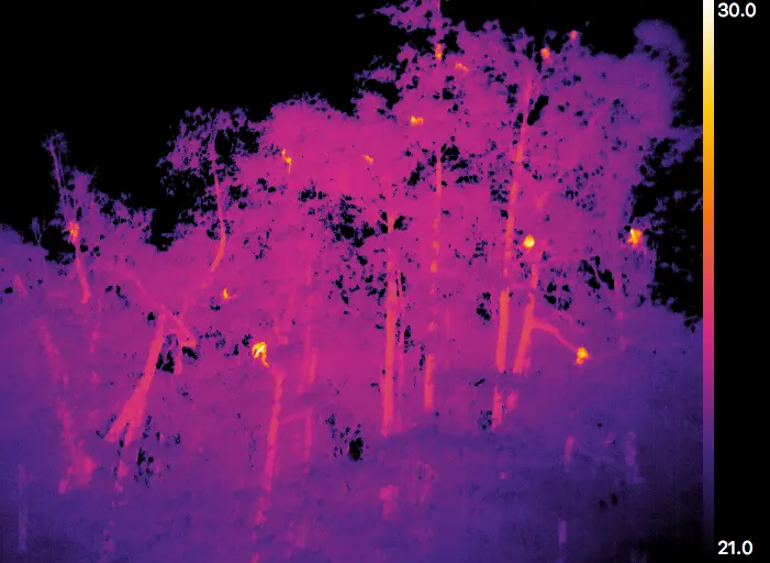
Urban Heat Island Effect Assessment

-
Service Overview: With the use of thermal imaging on the DJI M350, we provide assessments of the Urban Heat Island (UHI) effect in city areas. By detecting temperature variations across urban spaces, this service helps councils identify areas where excessive heat is being generated, contributing to climate change and negatively impacting local residents.
-
Key Benefits
-
Accurate Temperature Mapping: Thermal cameras provide precise temperature mapping, identifying hotspots where heat is trapped, such as poorly shaded areas or dense urban zones.
-
Actionable Data for Urban Planning: This data enables councils to make more sustainable decisions regarding green space development, shading, and energy-efficient buildings, ultimately improving the urban environment.
-
Cost-Effective Climate Action: Identifying and mitigating UHI effects early can help reduce the long-term costs associated with cooling infrastructure and energy consumption.
-
Wildlife Monitoring for Environmental and Habitat Protection
-
Service Overview: The DJI M350 with thermal camera technology provides efficient wildlife monitoring services, especially for councils managing natural reserves or urban wildlife corridors. The drones can detect heat signatures, making them ideal for night or day surveillance of wildlife populations, especially in remote or protected areas.
-
Key Benefits
-
Minimized Disruption: Drones allow for non-invasive wildlife monitoring, reducing the disturbance caused by traditional methods, and ensuring minimal impact on animal behavior.
-
Data-Driven Conservation Decisions: Thermal and wildlife data can inform habitat preservation strategies and help councils make data-driven decisions regarding wildlife corridors, conservation areas, and environmental policies.
-
Efficient Coverage of Large Areas: Covering vast distances in a short amount of time, drones help monitor large natural reserves, forests, and urban parks with ease, reducing the need for manual observation.
-
NDVI-Based Plant Health and Landscaping Monitoring
.jpg)
-
Service Overview: For councils and real estate developers focused on maintaining urban green spaces, parks, and gardens, our NDVI sensors (on the DJI M350) provide valuable insights into the health of vegetation. By analyzing the reflectance of light from plants, NDVI technology detects stress in vegetation caused by factors like drought, pests, or disease.
-
Key Benefits
-
Early Detection of Plant Stress: NDVI sensors allow for early identification of areas where plants are stressed or unhealthy, which can help councils and property developers take immediate action to maintain attractive green spaces.
-
Efficient Coverage of Large Areas: Drones can quickly assess large parks, golf courses, or estates, reducing the time and labor involved in manual surveys.
-
Improved Resource Allocation: Identifying areas that require extra irrigation, fertilization, or pest control allows you to allocate resources more effectively, reducing waste and cost.
-
Sustainable Landscape Management: Using NDVI data helps councils make informed decisions regarding sustainable land management and vegetation health.
-

Why Choose Our Real Estate and Councils Services?
-
Advanced Drone Technology for Unmatched Precision: Our fleet includes DJI Air 3 and DJI M350 drones equipped with thermal cameras and NDVI sensors, ensuring the most precise and detailed data collection for property inspections, wildlife monitoring, and environmental health assessments.
-
Speed, Efficiency, and Cost-Effectiveness: Drones significantly reduce the time required to capture high-quality data and imagery, offering faster turnaround times for property marketing, wildlife monitoring, and environmental surveys. This speed translates to cost savings, making it an ideal solution for both real estate developers and councils.
-
Tailored Solutions for Real Estate and Council Needs: Whether you're a real estate developer looking to showcase properties or a council needing comprehensive environmental monitoring, we offer customized solutions that cater to your specific requirements, ensuring that you get the most value out of our services.
-
Non-Invasive and Safe Monitoring: All of our drone services are designed to minimize disturbance to both wildlife and local ecosystems. We adhere to strict safety guidelines to ensure both the drones and operators work in compliance with local regulations, reducing risks while capturing vital data.